
Most people couldn’t have found Watford City on a map twenty years ago. Now it’s the center of one of the most significant oil-producing regions in North America — and understanding why tells you something important about how energy booms actually work.
There are places that exist in the background of national awareness and then, almost without warning, become critical. Watford City, North Dakota was a small ranching and farming community for most of its history — population a few thousand, county seat of McKenzie County, the kind of town that shows up in state records but not national conversations.
Then the Bakken happened. And Watford City didn’t just participate in the oil boom — it became its geographic and operational center. Understanding why Watford City became the heart of the Bakken oil field is understanding the specific geography, infrastructure, and community character that turned a small North Dakota town into one of the most economically active places in the American energy industry.
The Bakken Formation: A Geological Primer
The Bakken oil field isn’t a surface feature — it’s a geological formation that sits roughly two miles underground, running beneath a large portion of western North Dakota, eastern Montana, and extending into Saskatchewan and Manitoba in Canada. The formation is a shale and dolostone sequence of rock layers deposited roughly 360 million years ago and saturated with oil that, until horizontal drilling and hydraulic fracturing technologies matured in the early 2000s, was essentially inaccessible.
The Bakken formation holds an estimated 7.4 billion barrels of technically recoverable oil, according to the United States Geological Survey — one of the largest onshore oil discoveries in American history. The production surge that came with widespread horizontal drilling deployment from roughly 2008 onward transformed North Dakota into one of the top oil-producing states in the country, regularly ranking second only to Texas.
What this means for Watford City specifically is that the most productive zone of the Bakken formation runs almost directly beneath McKenzie County. Not near Bismarck. Not near Fargo. Right there, under the ground that farmers and ranchers had been working for generations without knowing what was underneath.
“The Bakken didn’t choose Watford City. The geology did. Once the drilling technology caught up to the resource, the city’s role was inevitable.”
Why Watford City Specifically — and Not Somewhere Else
North Dakota has several towns in the Bakken corridor — Williston, Tioga, Stanley, Minot as a larger hub to the east. Each of them grew with the boom. But Watford City, ND became the operational hub in ways that the others didn’t, and the reasons are a combination of geography, infrastructure, and the specific location of the most productive wells.
Geographic Positioning
Watford City sits at the junction of US Highway 85 running north-south and the access corridors into the most productive sections of the Williston Basin. The town became a natural staging and service point for oilfield operations across a wide geographic reach because its road connections allowed efficient movement of equipment, personnel, and materials in multiple directions without requiring passage through Williston itself.
The Little Missouri River terrain south and west of Watford City — the badlands that include Theodore Roosevelt National Park — acts as a natural boundary that concentrates infrastructure and services on the Watford City side. Workers heading to wells south of the Missouri River route through Watford City. Workers heading to wells north and east do the same. The town ended up at the hub of a spoke-and-wheel configuration that the geography imposed rather than planned.
The McKenzie County Production Profile
McKenzie County has consistently been among the top oil-producing counties in North Dakota — often producing more barrels per day than entire oil-producing states elsewhere in the country. When the core production is concentrated in a single county and Watford City is the county seat and primary service center, the relationship between the city and the oil industry is structural rather than incidental.
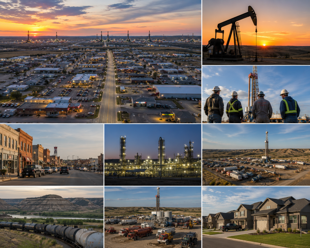
The Boom: What Growth at This Scale Actually Looks Like
Working in the Bakken during the peak years of the boom required housing, food, services, fuel, equipment, and the full range of support infrastructure that a large mobile workforce generates demand for. Watford City’s population grew from roughly 1,700 in 2010 to estimates as high as 10,000 or more during peak activity — a growth rate that compressed decades of normal city development into less than five years.
New housing developments appeared faster than permits could be processed. Schools were overcrowded within months of opening. Restaurants had wait lists. Hotels and man camps — the temporary industrial housing complexes used for oilfield workers — dotted the landscape outside the city limits. Traffic on US-85 that had been manageable for a small farming town became significant commercial truck traffic around the clock.
The tax revenue from oil production — North Dakota’s oil production tax formula delivers meaningful revenue to producing counties — funded infrastructure investment in Watford City at a scale that would have taken generations under normal growth. New roads, new schools, a new recreation center, new commercial development that served a population that had tripled in less than a decade.
The Price Cycle Reality
The Bakken boom, like every energy boom before it, cycled. Oil prices collapsed in 2014-2015 and the rapid expansion contracted. Workers left. Man camps emptied. Some of the businesses that had opened to serve peak demand couldn’t sustain themselves at lower activity levels. Watford City went through the same painful adjustment that energy boom towns always do when the cycle turns.
But unlike some boom towns that contract back to pre-boom status and then some, Watford City retained a meaningful portion of its growth. The permanent infrastructure built during the boom remained. A substantial year-round population had put down roots. The North Dakota oilfield didn’t stop producing — it stabilized and continued, at lower activity levels but with sustained output. Watford City stabilized with it, emerging from the contraction as a genuinely larger and more developed community than the one that existed before 2008.
Community Character: More Than Just an Energy Town
It would be easy to characterize Watford City purely through its oil industry lens — and plenty of coverage has done exactly that. But the community that exists here has a character that predates the boom and that has shaped how the boom was absorbed.
The ranching and farming heritage of McKenzie County is genuine and persistent. The families who have been here for generations didn’t disappear when the industry arrived — they adapted, many of them benefiting significantly from mineral rights income and service industry opportunities, and they continue to define a community culture that has rural North Dakota roots alongside the oilfield workforce identity that developed around them.
The proximity to Theodore Roosevelt National Park — both the North Unit and the South Unit are within driving distance of Watford City — gives the town an outdoor recreation dimension that’s unusual for an industrial hub. The badlands terrain, the wildlife (bison herds in both units), and the solitude of the Little Missouri River valley are all accessible from a Watford City base. For oilfield workers on days off and for the growing number of travelers who pass through the region, this combination of industry and wilderness is one of the more unexpected things about Watford City ND.
For travelers and workers looking to base themselves near both the oilfield services and the national park experience, the RV park near Theodore Roosevelt National Park puts you in the right position for both dimensions of the Watford City experience. And for everything about accommodations in the area, Watford City RV Park is the natural starting point.
Bakken by the numbers: The Bakken formation covers approximately 200,000 square miles across North Dakota, Montana, and southern Canada. North Dakota has consistently ranked second among U.S. oil-producing states, behind only Texas. McKenzie County alone has at times produced more than 150,000 barrels of oil per day. The USGS estimates 7.4 billion barrels of technically recoverable oil in the Bakken and Three Forks formations. Watford City is the county seat of McKenzie County and the primary service hub for this production zone.
What Working in the Bakken Actually Means Day to Day
For the thousands of workers who have come to the Bakken from every state in the country, the experience of working in the Bakken has a specific texture that’s worth understanding if you’re considering it or if you’re curious about the community you’re traveling through.
Oilfield work in the Bakken is physically demanding, weather-tested, and financially compensated at rates that reflect both the value of the work and the conditions under which it’s done. North Dakota winters are real — temperatures regularly below zero, windchill that makes those temperatures feel considerably colder, and operational conditions that require equipment and personnel specifically prepared for extreme cold. Workers who arrive without that preparation have a difficult adjustment period.
The shift structures are specific to the industry — many workers operate on rotations of two weeks on and one week off, or similar configurations, which creates a community of people who are intensely present for periods and then largely absent. This rotation pattern shapes everything from the town’s restaurant demand patterns to its social life to the housing market, where short-term and medium-term accommodations for rotating workers remain a persistent need that standard residential housing doesn’t fully address.
Watford City Today: A Town That Grew Up
The Watford City that exists now is neither the small farming community of 2005 nor the overcrowded boom town of 2012. It’s something that emerged from both — a small city with genuine community character, functioning infrastructure, the economic base of a major energy-producing county, and the outdoor recreation access that most industrial hubs lack entirely.
For people coming to work here, to pass through, or simply to understand what the modern American energy industry looks like on the ground, Watford City is the right place to start. It’s the heart of the Bakken not just because the geology put it there, but because the community that grew up around that geology built something worth staying for.
Frequently Asked Questions
Where is Watford City, ND located?
Watford City is the county seat of McKenzie County in western North Dakota, located on US Highway 85 approximately 70 miles north of the South Unit of Theodore Roosevelt National Park and roughly 20 miles from the North Unit. It sits in the heart of the Williston Basin, the geological formation that underlies the Bakken oil-producing region. The nearest large city is Bismarck, approximately 200 miles to the southeast, though Williston — about 60 miles north — is the other major service center in the Bakken corridor.
What is the Bakken oil field and how significant is it?
The Bakken is a shale and dolostone geological formation approximately two miles underground that runs beneath western North Dakota, eastern Montana, and portions of southern Canada. The USGS estimates 7.4 billion barrels of technically recoverable oil in the Bakken and Three Forks formations combined. North Dakota’s production from the Bakken has consistently ranked the state as the second-largest oil producer in the United States. The horizontal drilling and hydraulic fracturing technologies that unlocked Bakken production in the mid-2000s fundamentally changed U.S. oil production capacity and reduced American dependence on imported oil during the following decade.
What is it like to work in the Bakken oilfield?
Bakken oilfield work is physically demanding, weather-intensive, and well-compensated compared to most manual labor alternatives. Most workers operate on rotation schedules (typically two weeks on, one week off, or similar configurations) rather than standard five-day work weeks. North Dakota winters require specific cold-weather preparedness — temperatures regularly below zero with significant windchill. Housing in the Watford City area ranges from man camps (industrial housing complexes) to apartments and short-term rentals, with availability and pricing fluctuating with oil price and activity levels. Workers considering Bakken employment should research current activity levels, which are tied to oil prices, before relocating.
Is Watford City a good place to live long-term?
For people who value outdoor access, community character, and economic opportunity in an uncrowded environment, Watford City has genuine long-term appeal. The proximity to Theodore Roosevelt National Park’s North and South Units gives residents access to outstanding badlands terrain, wildlife, and wilderness recreation within a short drive. The community has developed genuine infrastructure — schools, healthcare, recreation facilities — during the boom that persists as community assets. The winters are demanding by most standards. The landscape is stark and beautiful in a way that suits some people enormously and doesn’t suit others at all. Whether it’s a good long-term home depends heavily on what you value in a place.
What is the current status of the Bakken in 2026?
As of 2026, the Bakken continues to produce significant oil volumes, though activity levels are tied to prevailing oil prices and the specific economics of tight oil production. North Dakota remains a top-two U.S. oil-producing state. Production technology has continued to improve, with longer lateral wells and more efficient completion techniques maintaining productivity at lower per-barrel costs than the early boom years. The Watford City area remains an active service and operational hub, with the community character of a stabilized energy town rather than the rapid-growth boom environment of 2010-2014.
What outdoor activities are available near Watford City?
Theodore Roosevelt National Park is the primary outdoor destination near Watford City — the North Unit is approximately 20 miles south and the South Unit is about 70 miles south. Both units offer hiking, wildlife viewing (bison herds are a highlight), scenic drives through badlands terrain, and camping. The Little Missouri River provides fishing access. The surrounding national grasslands and McKenzie County landscape offer hunting (deer, antelope, upland birds) and dispersed outdoor recreation. The area’s low population density means outdoor experiences that are genuinely uncrowded even in peak visitor seasons.