

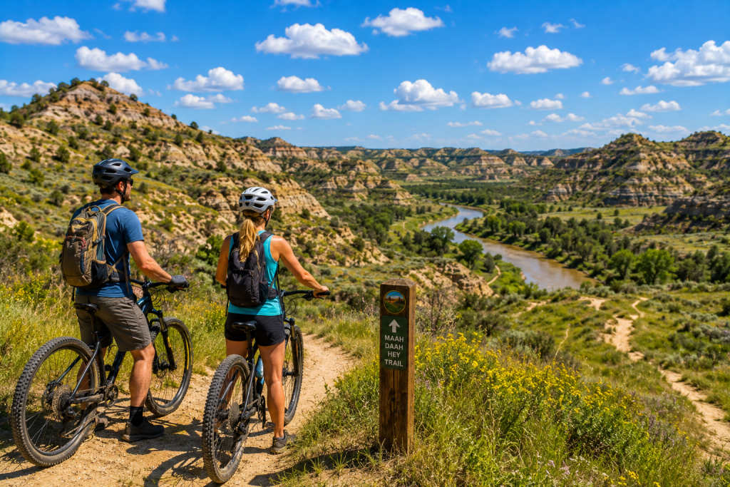
The Maah Daah Hey Trail is 144 miles of backcountry trail through the North Dakota Badlands — buttes, coulees, juniper draws, prairie ridgelines, and the Little Missouri River corridor threading through it all. You can thru-hike it in eight days or you can take a 6-mile section on a summer morning and be back at the campsite before the afternoon heat gets serious. This guide covers the day-trip version, specific to July.
The Maah Daah Hey — the name comes from Mandan for “an area that has been or will be around for a long time” — runs from the south unit of Theodore Roosevelt National Park near Medora all the way to the CCC Campground in the North Unit, 14 miles south of Watford City. That North Unit connection is what makes the trail a legitimate day-trip destination for people staying in Watford City rather than Medora. You don’t need to drive two hours south to access one of the most celebrated backcountry trails in the Northern Plains. You’re already there.
Understanding the Trail Before You Go
The Maah Daah Hey Trail is managed by the Bureau of Land Management in partnership with the National Park Service, Forest Service, and Custer Trails. The full 144-mile route runs through three units: sections adjacent to the North Unit of Theodore Roosevelt National Park (the northern end, closest to Watford City), the Long X Unit through the BLM badlands between the park units, and sections near the South Unit and Medora at the southern end.
For day-trip purposes from Watford City, the most accessible sections are at the northern end of the trail — specifically the segments accessible from the CCC Campground trailhead (the northern terminus) and the Burning Coal Vein Campground section roughly 20 to 30 miles south of Watford City on ND-85 and Wilderness Canyon Road. The trail is marked by brown carsonite posts with a turtle logo, which is the symbol the trail’s original designers chose for a trail intended to outlast its creators. The turtle appears at regular intervals so hikers can confirm they’re still on-route in terrain where the lack of obvious landmarks can be disorienting.
“The Maah Daah Hey has a character that you don’t get from other trails in the region. There are no trees to use as shade reference, no lake to serve as a destination, no obvious landmark to walk toward. It’s a trail through terrain that rewards paying attention to terrain rather than checking off summits.”
July Hiking on the Maah Daah Hey: The Honest Picture
July is not the easiest month to hike the Maah Daah Hey, and being clear about this prevents an unpleasant surprise. The trail is exposed — heavily, consistently exposed — to the North Dakota summer sun. There is essentially no tree canopy on the badlands sections. The clay soils absorb and radiate heat efficiently. On a July day when the air temperature is 90°F in the shade, the ground temperature on the clay butte surfaces you’re hiking across can be measurably higher.
That said, the 16 hours of daylight at this latitude in July produce something the southern sections of the trail don’t have: a morning window that is both cool and spectacularly lit. At 5:45 to 7 a.m. in early July, the sun is low, the shadows are long across the clay buttes, the air is in the upper 60s°F, and the badlands terrain looks the way landscape photographers specifically travel to capture it. Starting a Maah Daah Hey day hike at 6 a.m. and completing 8 to 12 miles before 10 a.m. — before the exposed terrain becomes genuinely demanding — is the summer edition strategy that makes July a viable hiking month on this trail.
The Best Day-Trip Segments From Watford City
Segment 1: CCC Campground to the North Unit Boundary — ~6 miles round trip
The northern terminus of the Maah Daah Hey is at the CCC Campground in Theodore Roosevelt National Park’s North Unit, 14 miles south of Watford City on US-85. The trail runs south from here into the BLM badlands — the first 3 miles south of the CCC Campground trailhead give a genuine badlands experience without committing to the distances that the full trail requires. The return on the same route keeps logistics simple: one car at one trailhead, no shuttle required. The terrain here is the butte-and-coulee character that defines the Maah Daah Hey — clay terrain, juniper draws, panoramic views from the ridgelines.
Segment 2: Burning Coal Vein Campground — An Accessible Mid-Trail Section
Burning Coal Vein Campground is located along Forest Service Road 872, accessed from Wilderness Canyon Road south of Watford City — approximately 25 to 35 miles south of Watford City by road. This BLM campground sits directly on the Maah Daah Hey and is one of the more accessible mid-trail trailhead access points for day hikers coming from the north. The terrain around the Burning Coal Vein section includes the geological feature the campground is named for — lignite coal seams that have been burning underground for centuries, producing steaming and brightly colored oxidized clay formations. It’s one of the more geologically unusual sections of the trail and gives the day hike a visual specificity beyond the general badlands landscape.
The Lone Butte and Bennett Creek Sections
For hikers willing to drive further south along ND-85 and access the Long X Unit BLM sections, the Lone Butte and Bennett Creek areas give longer day-hike options with camping alternatives if the day extends into an overnight. These sections are further from Watford City (50 to 60 miles south by road) but are among the trail’s most visually dramatic segments — the terrain complexity and the Little Missouri River views in these sections are what trail veterans consistently describe as the Maah Daah Hey’s best country. A day hike here requires an early departure from Watford City (5 to 5:30 a.m.) for the drive, the morning hike, and the return in the same day — ambitious but achievable in summer’s extended daylight.
What You Need for a Summer Maah Daah Hey Day Hike
The gear list for an exposed badlands trail hike in July is specific and unforgiving about omissions.
Water is the non-negotiable item. There is no reliable water source on the Maah Daah Hey — the Little Missouri River is present in sections but is not potable without treatment, and the clay terrain holds no springs or streams accessible from the trail. The standard recommendation is one liter of water per hour of hiking in hot weather. A 6-mile morning hike that takes 3 hours requires at minimum 3 liters per person; packing 4 is not overcautious for a July day. Insulated bottles extend the cold-water window significantly — warm water in a hot July on an exposed clay trail is better than nothing, but cold water is more actively hydrating because it’s more appealing to drink in sufficient quantity.
Sun protection is the second critical item. A wide-brim hat that shades the face, ears, and back of the neck. SPF 50 or higher sunscreen applied before departing and brought for reapplication — exposed clay terrain reflects UV radiation upward as well as receiving it from above, creating a double-exposure effect that makes sunburn significantly faster than on shaded forest trails. A light long-sleeve moisture-wicking layer can replace reapplication on the back and arms for hikers who prefer fabric coverage over chemical sunscreen.
Footwear matters specifically here. The clay soils on the Maah Daah Hey become extremely slippery when wet — either from rain or from morning dew in the coulees — and trail runners or hiking shoes with appropriate tread are significantly safer on wet clay than road running shoes or light sandals. The July monsoon season means afternoon thunderstorms are possible; starting early enough that you’ve completed the exposed sections before afternoon storm development is both a safety and a comfort consideration.
Maah Daah Hey summer day-trip quick reference: Trail total: 144 miles, Medora to CCC Campground (North Unit). Turtle logo markers on brown carsonite posts. Closest trailhead to Watford City: CCC Campground, North Unit TRNP, 14 miles south on US-85. Best summer start time: 6:00 a.m. to complete exposed sections before midday heat. Water: 1 liter per hour minimum. No potable water on trail. Insulated bottles keep water cold longer. Sun protection: wide-brim hat, SPF 50+, light long-sleeve layer. Clay terrain reflects UV upward — sunburn is faster than on shaded trails. Footwear: trail runners or hiking shoes with appropriate tread. Clay soils are slippery when wet. Storm awareness: July monsoon season. Morning start ensures you’re off exposed terrain before afternoon thunderstorm development. Navigation: GAIA GPS app with offline North Dakota MDH track downloaded before departure. Cell coverage is minimal in the backcountry.
For oilfield workers and long-term residents using Watford City as a base who want to explore the trail across multiple off-rotation days, the monthly RV sites in Watford City give the extended-stay option. For Bakken workforce visitors specifically, the oilfield worker housing at Watford City RV Park covers the base camp logistics. Visitors approaching from the Williston corridor to the northwest can check the RV park near Williston, ND page. And for planning any stay that makes the Maah Daah Hey accessible as a morning day trip, Watford City RV Park is the starting point.
Frequently Asked Questions
How long is the Maah Daah Hey Trail and how much of it can I do in a day trip?
The Maah Daah Hey Trail is 144 miles total, running from the south unit of Theodore Roosevelt National Park near Medora to the CCC Campground in the North Unit, approximately 14 miles south of Watford City. A day trip from Watford City realistically covers 6 to 12 miles depending on fitness level, heat, and which section you access. The CCC Campground trailhead (the northern terminus, 14 miles south of Watford City on US-85) gives immediate trail access for a 6-mile round trip or longer out-and-back. The Burning Coal Vein Campground section (25 to 35 miles south by road) gives a mid-trail day-hike option with the geologically unusual burning coal vein formations. For an 8 to 12-mile day in July, starting at 6 a.m. and completing before the midday heat peaks is the practical approach.
Is the Maah Daah Hey Trail safe to hike in July?
Yes, with appropriate preparation. The primary summer safety considerations are heat and sun exposure on an almost entirely exposed trail, adequate water carry (minimum 1 liter per hour of hiking — there is no potable water on the trail), afternoon thunderstorm awareness during the July monsoon season, and navigation in terrain without obvious landmarks. Starting at or before sunrise, completing the exposed sections before midday, carrying more water than you think you need, wearing wide-brim sun protection, and having a navigation app with offline trail data downloaded before departure addresses all of these. The trail is not technically demanding — there are no scrambles or significant technical sections — but the combination of heat, exposure, and remote terrain requires more active preparation than a shaded forest trail in more temperate conditions.
What is the closest Maah Daah Hey trailhead to Watford City?
The closest Maah Daah Hey trailhead to Watford City is the CCC Campground in Theodore Roosevelt National Park’s North Unit — the northern terminus of the trail, located approximately 14 miles south of Watford City on US-85. From the CCC Campground, the trail runs south through the park and into BLM lands. The park day-use fee ($35/vehicle 7-day pass or America the Beautiful annual pass) applies for access through the North Unit to reach this trailhead. Alternatively, some sections of the trail accessible from BLM-managed Forest Service roads south of the park can be reached without a park entry fee — the Burning Coal Vein Campground section accessed via Wilderness Canyon Road and Forest Service Road 872 is one such access point, though the approach road requires attention in wet conditions.
Are there any trees or shade on the Maah Daah Hey Trail?
Shade on the Maah Daah Hey is minimal and intermittent — the trail traverses largely open badlands terrain dominated by clay buttes, grassland ridgelines, and occasional juniper draws where some limited canopy exists. The juniper-lined coulee bottoms provide the closest thing to shade the trail offers, and planning rest stops in these areas rather than on the exposed ridgelines makes a meaningful difference in heat management during the summer months. There are no sections of the Maah Daah Hey that provide sustained canopy shade comparable to a forested trail — the open character of the badlands is part of the trail’s defining visual experience and also its primary summer challenge. Arriving at sunrise and hiking through the morning window before the sun reaches full intensity is the heat management strategy that makes July hiking on the trail viable.
What navigation tools should I bring for the Maah Daah Hey?
Navigation on the Maah Daah Hey requires more preparation than a well-marked park trail. The brown carsonite turtle posts appear at regular intervals and confirm route direction, but the open, landmark-light badlands terrain can make orientation difficult for hikers without experience in this type of environment. Cell coverage is minimal to nonexistent in most of the backcountry BLM sections of the trail. The practical navigation setup: download the GAIA GPS app on your phone and download the North Dakota section of the Maah Daah Hey as an offline track before departure. A paper topo map of the section you’re hiking as a backup. The BLM Maah Daah Hey Trail Guide (available from the BLM Dickinson Field Office or downloaded at blm.gov) provides the official route description and trailhead access information. A charged external battery pack ensures your phone navigation doesn’t die mid-route.
What is the best Maah Daah Hey section for a first-time visitor?
For a first-time visitor doing a July day trip from Watford City, the CCC Campground section (northern terminus, 14 miles south on US-85 through the North Unit) is the best starting point — it’s the closest to Watford City, it gives a genuine badlands trail experience, and the 6-mile round trip is achievable in the morning heat window without overextending. The Burning Coal Vein Campground section (approximately 30 miles south by road) is worth the additional drive for a second visit — the geological character of the burning coal vein formations gives the section a specific visual interest beyond the general badlands landscape. Both sections use the same turtle-logo marking system and give the same fundamental Maah Daah Hey experience; the CCC Campground section is simply the more accessible starting point for someone orienting to the trail for the first time from a Watford City base.
Trail information sourced from the BLM Dickinson Field Office’s Maah Daah Hey Trail Guide and Theodore Roosevelt National Park North Unit visitor information. Check current trail conditions through the BLM Dickinson Field Office (blm.gov/office/dickinson-field-office) before visiting — spring flooding and wet conditions can affect trail surface in the clay terrain segments.